

Norma slams into Mexico’s southern Baja California Peninsula, lashing region with heavy rain, high winds
Norma made landfall Saturday as a Category 1 hurricane along Mexico’s Baja California coast, bringing large waves, flooding and wind gusts higher than 75 mph.
The once Category 4 hurricane weakened significantly before it made landfall south of Cabo San Lucas, which helped spare some communities surrounding the popular tourist destination from more extensive damage.
Flooding from rainfall was reported around the Baja California Peninsula, with at least 4 inches of rain falling over the past few days.
An elevated weather station in the hills overlooking Cabo San Lucas reported multiple wind gusts of more than 90 mph, with a peak gust of 107 mph.
Several retail centers near the coast were closed due to the hazardous weather.
CAN TROPICAL CYCLONES MAKE IT ACROSS THE ENTIRE PACIFIC OCEAN?
Norma has since been downgraded to a tropical storm, and forecasters say Norma will continue to weaken as it continues to push closer to the western coast of mainland Mexico ahead of a second landfall on Sunday.
Tropical Storm Warnings have been issued by the Mexican government for coastal communities from Santa Fe to San Evaristo and from Huatabampito to Mazatlan.
DEADLY HURRICANE LIDIA BECOMES ONE OF MEXICO'S STRONGEST LANDFALLING PACIFIC HURRICANES
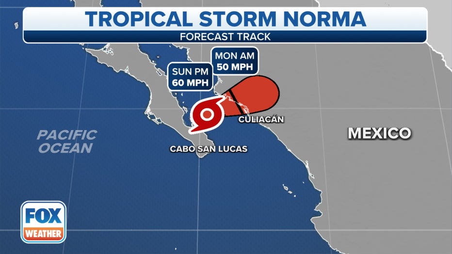
The forecast cone for Hurricane Norma.(FOX Weather)
Rainfall totals were forecast to reach 6 to 12 inches, with localized amounts up to 18 inches, across the southern portion of Baja California Sur through Sunday and through Sinaloa into Monday, according to the National Hurricane Center (NHC).
The heavy rain will produce flash and urban flooding, along with mudslides in higher-terrain areas.
Videos from the region as Norma neared landfall on Saturday showed heavy rain and high winds lashing coastal communities, with palm trees bending during the stronger gusts. In addition to the rain and wind, large waves battered the coast.
Coastal flooding was reported during the storm, but the NHC said that should gradually subside on Sunday along the coast of Baja California Sur. Coastal flooding is possible along the west coast of mainland Mexico within the Tropical Storm Warning area. Near the coast, the flooding will be accompanied by large and dangerous waves.
The heavy rainfall triggered local authorities to move pumps to low-lying areas to help protect infrastructure and minimize road closures.
The government encouraged those in Norma's path to stay sheltered while the worst of the impacts moved through.
Norma's remnants to eventually soak Desert Southwest, southern Plains
Norma will lose its tropical characteristics Monday after pushing ashore in the mountainous terrain of Sinaloa, but its deep surge of moisture will live on. It will push into the Desert Southwest early this week and give the southern Plains a one-two dose of tropical moisture.
"If there’s any little baby silver lining in all of this, it’s that the remnants of Norma should actually produce some welcome rain for the Lone Star State of Texas," FOX Weather meteorologist Michael Estime said.
Rainfall is expected to begin Monday in Texas before spreading northward Tuesday.
REMNANTS OF HURRICANE NORMA WILL HELP BRING DROUGHT RELIEF TO TEXAS, OKLAHOMA
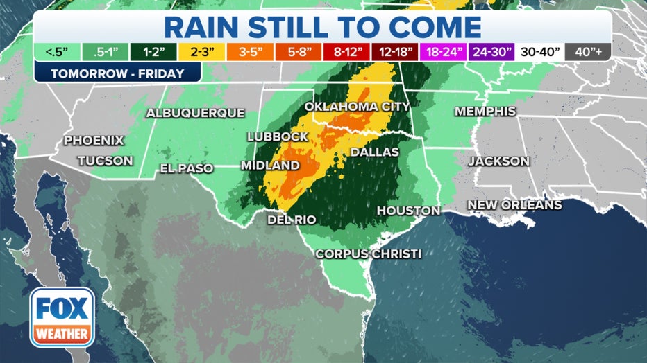
Norma's moisture will head into the southern Plains.(FOX Weather)
FOX Forecast Center also tracking Invest 91E
Meanwhile, a second tropical disturbance several hundred miles southeast of Norma could become the next tropical cyclone in the Eastern Pacific.
The NHC has given an area of disturbed weather a high chance of developing over the next few days.
Recent satellite wind data indicated that the circulation associated with the system has become better defined, but the associated shower and thunderstorm activity is displaced well to the northwest and west of the center.
Conditions will be more conducive for development, and a tropical depression will likely form in the next few days.
If the disturbance organizes into a tropical storm, it will be named Otis.
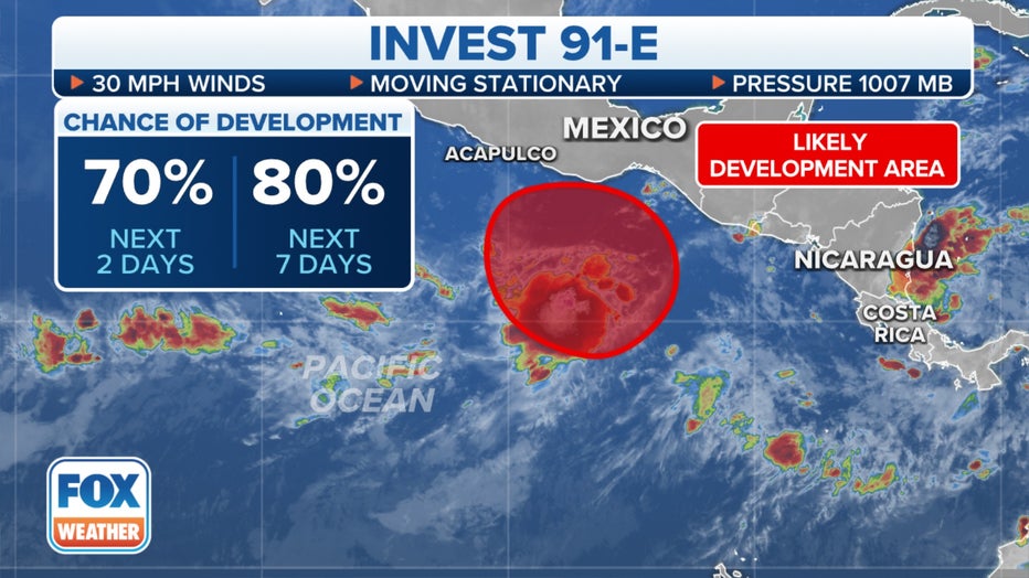
Invest 91E swirls in the Eastern Pacific.(FOX Weather)