Flood Watch
until MON 5:00 AM MST, Eastern Cochise County below 5000 ft including Douglas/Wilcox, Upper Gila River and Aravaipa Valleys including Clifton/Safford, Southeast Pinal County including Kearny/Mammoth/Oracle, Western Pima County including Ajo/Organ Pipe Cactus National Monument, Dragoon/Mule/Huachuca and Santa Rita Mountains including Bisbee/Canelo Hills/Madera Canyon, Tucson Metro Area including Tucson/Green Valley/Marana/Vail, Tohono O'odham Nation including Sells, Baboquivari Mountains including Kitt Peak, Upper San Pedro River Valley including Sierra Vista/Benson, Chiricahua Mountains including Chiricahua National Monument, Galiuro and Pinaleno Mountains including Mount Graham, Santa Catalina and Rincon Mountains including Mount Lemmon/Summerhaven, White Mountains of Graham and Greenlee Counties including Hannagan Meadow, South Central Pinal County including Eloy/Picacho Peak State Park, Upper Santa Cruz River and Altar Valleys including Nogales, Northwest Plateau, Lake Havasu and Fort Mohave, North Phoenix/Glendale, Aguila Valley, Mazatzal Mountains, Tonopah Desert, Gila Bend, San Carlos, East Valley, Northwest Pinal County, Northwest Valley, Southeast Valley/Queen Creek, Globe/Miami, Deer Valley, Fountain Hills/East Mesa, Apache Junction/Gold Canyon, Buckeye/Avondale, Tonto Basin, Rio Verde/Salt River, South Mountain/Ahwatukee, Dripping Springs, Southeast Gila County, Pinal/Superstition Mountains, Scottsdale/Paradise Valley, New River Mesa, Sonoran Desert Natl Monument, West Pinal County, Superior, Cave Creek/New River, Central Phoenix, Yavapai County Mountains, Little Colorado River Valley in Navajo County, Western Mogollon Rim, Coconino Plateau, Chinle Valley, Yavapai County Valleys and Basins, Oak Creek and Sycamore Canyons, Grand Canyon Country, Chuska Mountains and Defiance Plateau, Northeast Plateaus and Mesas South of Hwy 264, Little Colorado River Valley in Coconino County, Black Mesa Area, Marble and Glen Canyons, Northeast Plateaus and Mesas Hwy 264 Northward, Northern Gila County, White Mountains, Kaibab Plateau, Eastern Mogollon Rim, Little Colorado River Valley in Apache County

CDC map shows where flu cases have spiked in the US

Published November 23, 2022 12:56 PM MST

As U.S. health officials continue to push for people to get their COVID-19 boosters, they also want to make sure you don't forget about flu season. 

More than half of U.S. states have high or very high levels of flu, unusually high for this early in the season, the government reported last week. Those 27 states are mostly in the South and Southwest but include a growing number in the Northeast, Midwest and West.

As Americans gear up for holiday travel, the U.S. Centers for Disease Control and Prevention has published a seasonal flu tracker to help people be aware of the spread of the illness. 
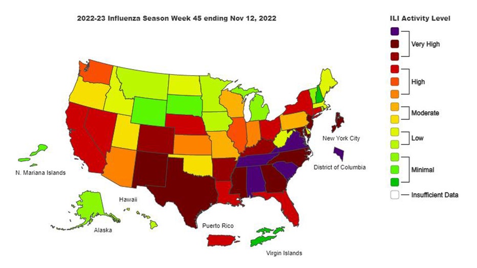
CDC-flu-map (1)

CDC flu map

See the full interactive map here

This year's uptick in flu cases is happening when children’s hospitals already are dealing with a surge of illnesses from RSV, or respiratory syncytial virus, a common cause of coldlike symptoms that can be serious for infants and the elderly. And COVID-19 is still contributing to more than 3,000 hospital admissions each day, according to the CDC. 

But busy flu season is not unexpected. The nation saw two mild seasons during the COVID-19 pandemic, and experts have worried that flu might come back strong as a COVID-weary public has moved away from masks and other measures that tamp the spread of respiratory viruses.

So far this season, there have been an estimated 1.6 million flu illnesses and 13,000 hospitalizations. Flu activity is most intense in some areas where RSV is fading, including the Southeast, according to CDC data.

This story was reported from Los Angeles. The Associated Press contributed. 

NewsHealthU.S.