Flood Watch
until MON 5:00 AM MST, Eastern Cochise County below 5000 ft including Douglas/Wilcox, Upper Gila River and Aravaipa Valleys including Clifton/Safford, Southeast Pinal County including Kearny/Mammoth/Oracle, Western Pima County including Ajo/Organ Pipe Cactus National Monument, Dragoon/Mule/Huachuca and Santa Rita Mountains including Bisbee/Canelo Hills/Madera Canyon, Tucson Metro Area including Tucson/Green Valley/Marana/Vail, Tohono O'odham Nation including Sells, Baboquivari Mountains including Kitt Peak, Upper San Pedro River Valley including Sierra Vista/Benson, Chiricahua Mountains including Chiricahua National Monument, Galiuro and Pinaleno Mountains including Mount Graham, Santa Catalina and Rincon Mountains including Mount Lemmon/Summerhaven, White Mountains of Graham and Greenlee Counties including Hannagan Meadow, South Central Pinal County including Eloy/Picacho Peak State Park, Upper Santa Cruz River and Altar Valleys including Nogales, North Phoenix/Glendale, Aguila Valley, Mazatzal Mountains, Tonopah Desert, Gila Bend, San Carlos, East Valley, Northwest Pinal County, Northwest Valley, Southeast Valley/Queen Creek, Globe/Miami, Deer Valley, Fountain Hills/East Mesa, Apache Junction/Gold Canyon, Buckeye/Avondale, Tonto Basin, Rio Verde/Salt River, South Mountain/Ahwatukee, Dripping Springs, Southeast Gila County, Pinal/Superstition Mountains, Scottsdale/Paradise Valley, New River Mesa, Sonoran Desert Natl Monument, West Pinal County, Superior, Cave Creek/New River, Central Phoenix, Northwest Plateau, Lake Havasu and Fort Mohave, Yavapai County Mountains, Little Colorado River Valley in Navajo County, Western Mogollon Rim, Coconino Plateau, Chinle Valley, Yavapai County Valleys and Basins, Oak Creek and Sycamore Canyons, Grand Canyon Country, Chuska Mountains and Defiance Plateau, Northeast Plateaus and Mesas South of Hwy 264, Little Colorado River Valley in Coconino County, Black Mesa Area, Marble and Glen Canyons, Northeast Plateaus and Mesas Hwy 264 Northward, Northern Gila County, White Mountains, Kaibab Plateau, Eastern Mogollon Rim, Little Colorado River Valley in Apache County

Groundhog Day 2026: What time will Punxsutawney Phil come out?
Published January 27, 2026 10:18 AM MST

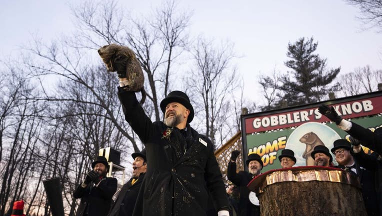
PENNSYLVANIA, UNITED STATES - FEBRUARY 02: Groundhog Club handler A.J. Dereume holds Punxsutawney Phil, the weather prognosticating groundhog, during the 139th celebration of Groundhog Day on Gobbler's Knob in Punxsutawney, Pennsylvania on February 2

It's that time of year again! Punxsutawney Phil is getting ready to make his winter prediction, but you'll have to wake up early if you want to see the famed groundhog.

What we know:

Punxsutawney Phil will reveal his annual winter prediction on Groundhog Day in front of a crowd of very excited spectators in Pennsylvania's Gobbler's Knob.

The rest of the nation will watch along from home to see if we are getting an early spring, or six more weeks of winter.

When is Groundhog Day?

Timeline:

Groundhog Day is always held on February 2, which is a Monday this year.

Festivities will begin at 3 a.m. onstage at Gobbler's Knob, and last through the afternoon. Phil is expected to emerge around sunrise, which is currently 7:07 a.m.

If the groundhog rises without seeing his shadow, Phil's official "interpreter" will read the spring proclamation!

For a full list of events, check out the Punxsutawney Groundhog Club.

What is Groundhog Day?

The backstory:

Groundhog Day originates from the Christian festival of Candlemas, a European tradition held on February 2 that uses a badger or hedgehog to predict the weather based on its shadow.

When German immigrants settled in Pennsylvania, they swapped the badger for a groundhog, because it was more common in the area.

The U.S. holiday appeared in a local newspaper in 1886, but the first official trip to Gobbler's Knob didn't happen until the following year.

The Source: Information from this article was sourced from the Punxsutawney Groundhog Club.

PennsylvaniaHolidaysWeatherNews