

Artemis II: First photos of Earth from Orion spacecraft
What does Earth look like from the vantage point of Artemis II's astronauts?
NASA released a handful of images on Friday of Earth, taken from space by Commander Reid Wiseman and others aboard the Orion spacecraft as they continue to make their way towards the moon's orbit.
Artemis II live tracker: How far is Orion spacecraft from the moon?
Artemis II photos of Earth
Where is Artemis II right now?
The backstory:
Artemis II lifted off from Kennedy Space Center in Florida on April 1 – the start of a 10-day mission to the moon and back.
On Thursday night, April 2, Orion's main engine provided nearly 6,000 pounds of thrust to push the spacecraft out of Earth's orbit and on its way towards the moon's orbit, where it will fly by the moon and then be brought back to Earth, NASA said.
There are four astronauts aboard:
- Commander Reid Wiseman
- Pilot Victor Glover
- Mission Specialist Christina Koch
- Mission Specialist Jeremy Hansen (Canadian Space Agency)
Artemis II live tracker
NASA has created the Artemis Real-time Orbit Website (AROW), where people can track the Orion spacecraft in real time. Click here to see where the spacecraft and the Artemis II astronauts are.
Watch live: NASA video feed from Orion spacecraft
Here is a live video feed from the Orion spacecraft.
"Viewers will see a blue screen if there is a loss of signal, or if the bandwidth is needed for mission activities. Viewers may see what appears to be a black screen when the vehicle is in darkness."
Timeline: How long does it take to reach the moon?
NASA’s Artemis II mission will orbit Earth for a day, travel to the moon for a flyby beyond its far side, and then return along a free-return trajectory, culminating in Orion’s reentry and a Pacific Ocean splashdown.
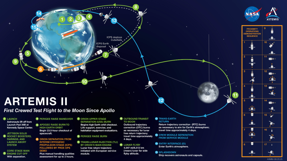
An illustration showing the Artemis II mission. Credit: NASA
- Earth orbit (Day 1): The Artemis II astronauts will orbit Earth for one day to confirm all spacecraft systems are functioning properly.
- To the moon (Days 2–5): Orion’s main engine will fire to propel the capsule out of Earth orbit toward the moon, roughly 244,000 miles (393,000 kilometers) away.
- Moon flyby (Day 6): Orion will reach its farthest point from Earth, passing about 5,000 miles (8,000 kilometers) beyond the moon. Astronauts are expected to document the flyby with cameras and smartphones before heading back to Earth.
- Return (Days 6–9): Using a free-return trajectory, Orion will use the moon’s and Earth’s gravity to guide the spacecraft safely home.
- Reentry: The service module separates, and the capsule re-enters Earth’s atmosphere, facing temperatures up to 3,000°F (1,650°C).
- Splashdown: The Artemis II crew will parachute into the Pacific Ocean, completing the mission much like Apollo astronauts did decades ago.
The Source: NASA released several images Friday morning via its Artemis II blog and NASA's social media accounts. Additional information pulled from NASA and Artemis II web pages, media guides, press conferences and live streams.