

Transition into El Nino could lead to record heat around globe

Extreme heat leads to more bugs seeking refuge inside homes
Tarrant County Pest Control owner Brent Russell says the summer heat in 2022 has led to a busy season for battling insects. (FOX Weather)
When the world’s largest and deepest ocean basin warms, satellites will be busy over the Pacific Ocean detecting analogous water temperatures but also, if history repeats itself, landmasses across the globe will have to deal with heat that could be record-breaking.
Since reliable technology started keeping track of world temperatures in the 1950s, the warmest year of any decade were periods dominated by an El Niño event, and the coldest were from La Niñas.
"During El Niño, unusually warm sea surface temperatures in the central/eastern tropical Pacific lead to increased evaporation and cooling of the ocean. At the same time, the increased cloudiness blocks more sunlight from entering the ocean. When water vapor condenses and forms clouds, heat is released into the atmosphere. So, during El Niño, there is less heating of the ocean and more heating of the atmosphere than normal," National Oceanic and Atmospheric Administration experts wrote in a 2022 ENSO blog.
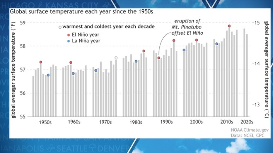
Tracking temperatures through the decades(NOAA)
The world’s last El Niño ended nearly four years ago, but it’s the event of 2015-16 that holds records for not only being one of the strongest El Niños on record but also causing the world’s warmest temperatures.
The year 2016 ended with temperatures around 1.8 degrees Fahrenheit above normal, making it the warmest period on record. During the dog days of summer, more than 124 million people were under extreme heat warnings in the U.S. as communities from the Southwest to the Southeast reported record heat.
END OF TRIPLE-DIP LA NINA IN SIGHT: WHAT IT COULD MEAN FOR SPRING SEVERE WEATHER SEASON
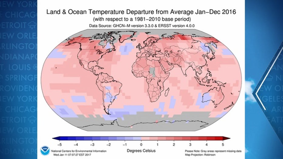
2016 world heat map(NOAA)
Uncertainty lies ahead, but signs point to continued warmth
The globe is currently still in a La Niña, which is expected to end in the coming months.
The climate pattern has been in control of weather for three years and made history by becoming the first triple-dip La Niña of the 21st century.
Also, during this phase, NOAA reported the world experienced some of its warmest temperatures ever, despite the pattern being known for its cooling effect.
The base mark of near-record heat has some climatologists concerned that once an El Niño is able to shake off the lagging effects of La Niña, temperatures could be off to the races and reach levels never seen before.
"The ongoing La Niña may prevent global average temperature from breaking the record in 2023, but greenhouse gas-induced global warming grows steadily in magnitude. In fact, it most likely helped 2020, a year of La Niña, to tie the all-time high of 2016, a year following a major El Niño," Shang-Ping Xie, a climate dynamicist at Scripps Institution of Oceanography, wrote in an ENSO discussion.
WHAT ARE EL NINO AND LA NINA CLIMATE PATTERNS?
Computer model guidance shows a trend towards the El Niño state, especially in the latter half of 2023 and possibly continuing into 2024.
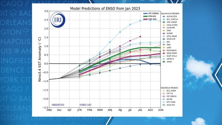
Tracking the end to the La Nina with climate models.(NOAA)
If history repeats itself, a protracted El Niño episode could result in warm, if not record-breaking, temperatures.
Significant questions remain on exactly when the world reaches the neutral state and begins the trek through El Niño. Some climate models prematurely killed off the current La Niña during its three-year stretch, so the exact timeframe of transition is not set in stone.
The rarity of a stubborn La Niña state and global temperatures that haven’t declined as readily as during past events, has some experts pointing to climate change as playing an increasingly pivotal role in patterns.
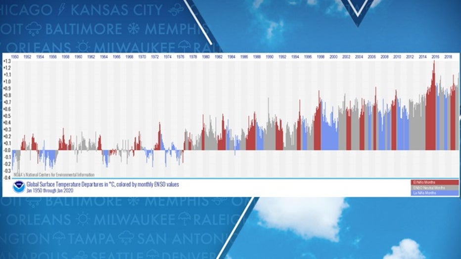
Monthly global temperature anomalies since January 1950(FOX Weather)
NOAA experts admit what is complicating outlooks are climate change’s influences on Pacific wind and water temperature patterns or what is known as the El Niño-Southern Oscillation.
"If temperatures warm faster in the western Pacific than in the eastern Pacific, the background tropical circulation could become more La Niña-like. But if the trend pattern changes as global temperatures continue to rise, meaning the east starts warming faster than the west in the future, the whole circulation across the tropical Pacific could become more El Niño-like," Michelle L’Heureux, a scientist at NOAA’s Climate Prediction Center, posted in a recent blog.