Flood Watch
until MON 5:00 AM MST, Eastern Cochise County below 5000 ft including Douglas/Wilcox, Upper Gila River and Aravaipa Valleys including Clifton/Safford, Southeast Pinal County including Kearny/Mammoth/Oracle, Western Pima County including Ajo/Organ Pipe Cactus National Monument, Dragoon/Mule/Huachuca and Santa Rita Mountains including Bisbee/Canelo Hills/Madera Canyon, Tucson Metro Area including Tucson/Green Valley/Marana/Vail, Tohono O'odham Nation including Sells, Baboquivari Mountains including Kitt Peak, Upper San Pedro River Valley including Sierra Vista/Benson, Chiricahua Mountains including Chiricahua National Monument, Galiuro and Pinaleno Mountains including Mount Graham, Santa Catalina and Rincon Mountains including Mount Lemmon/Summerhaven, White Mountains of Graham and Greenlee Counties including Hannagan Meadow, South Central Pinal County including Eloy/Picacho Peak State Park, Upper Santa Cruz River and Altar Valleys including Nogales, Northwest Plateau, Lake Havasu and Fort Mohave, North Phoenix/Glendale, Aguila Valley, Mazatzal Mountains, Tonopah Desert, Gila Bend, San Carlos, East Valley, Northwest Pinal County, Northwest Valley, Southeast Valley/Queen Creek, Globe/Miami, Deer Valley, Fountain Hills/East Mesa, Apache Junction/Gold Canyon, Buckeye/Avondale, Tonto Basin, Rio Verde/Salt River, South Mountain/Ahwatukee, Dripping Springs, Southeast Gila County, Pinal/Superstition Mountains, Scottsdale/Paradise Valley, New River Mesa, Sonoran Desert Natl Monument, West Pinal County, Superior, Cave Creek/New River, Central Phoenix, Yavapai County Mountains, Little Colorado River Valley in Navajo County, Western Mogollon Rim, Coconino Plateau, Chinle Valley, Yavapai County Valleys and Basins, Oak Creek and Sycamore Canyons, Grand Canyon Country, Chuska Mountains and Defiance Plateau, Northeast Plateaus and Mesas South of Hwy 264, Little Colorado River Valley in Coconino County, Black Mesa Area, Marble and Glen Canyons, Northeast Plateaus and Mesas Hwy 264 Northward, Northern Gila County, White Mountains, Kaibab Plateau, Eastern Mogollon Rim, Little Colorado River Valley in Apache County

Lightning-caused Bear Fire 18% contained; what you need to know about the wildfire
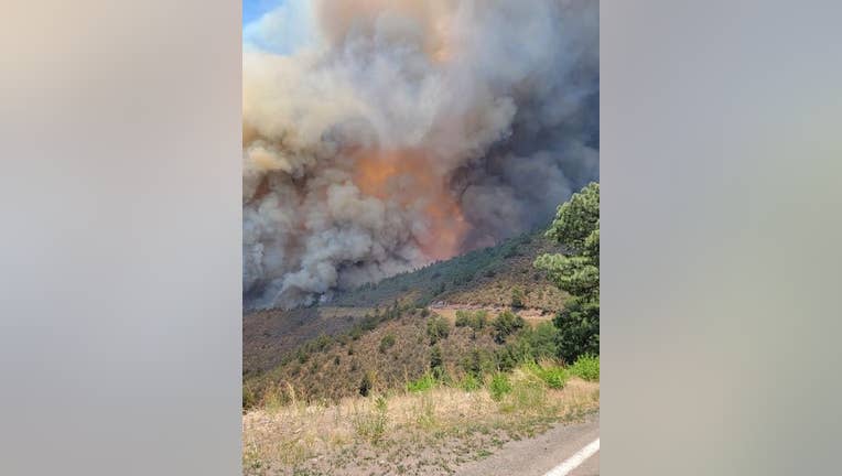
(Courtesy: Apache-Sitgreaves National Forest)

Fire officials say a wildfire that began on June 16 has burned 23,840 acres of land and is at 18% containment.

According to a statement released by officials with the Apache-Sitgreaves National Forest, the Bear Fire is burning 10 miles south of Hannagan Meadow, an area about 114 miles north of Safford. The fire was sparked by lightning.

"Due to the Bear’s location, fuels and values at risk, forest officials have chosen a confine/contain and point protection strategy for this incident which will reduce exposure to suppression resources," read a portion of the statement.

Closures and evacuations

Highway 191 closed on June 20. The closure is from milepost 175 to milepost 251. The closure will remain in effect until further notice.

Timeline of the Bear Fire:

June 28

The Bear Fire has grown to 23,481 acres and is 12% contained.

June 27

The Bear Fire has burned 19,214 acres of land and is 0% contained.

June 24

Forest officials say the fire is burning in an area with ponderosa pine, grass and brush. Meanwhile, smoke from the fire may impact Highway 191 and the Blue River.

You can search for current smoke information and view an interactive map at https://fire.airnow.gov

As a result of the fire, officials say Highway 191 is closed – southbound is closed at milepost 250 and northbound is closed at milepost 175.


More wildfire news

Tune in to FOX 10 Phoenix for the latest news

For the latest local news, download the FOX 10 News app

Sign up for FOX 10 email alerts, newsletters

WildfiresGreenlee CountyNews