

Squally weather expected in South Texas as tropical disturbance approaches

A tropical disturbance that remains disorganized over the Gulf of Mexico is expected to bring scattered showers, produce gusty winds and create rough seas for parts of northern Mexico and southern Texas through the weekend.
The system was dubbed Potential Tropical Cyclone Four by the National Hurricane Center. A PTC classification is simply a convention used by the NHC to identify a disturbed area of weather that has the potential to impact land as an organized tropical cyclone during the next few days.
WHAT IS A POTENTIAL TROPICAL CYCLONE?
The NHC says chances are dropping that disturbance strengthens into Tropical Storm Danielle before making landfall south of the Rio Grande, but the lack of organization will not change impacts.
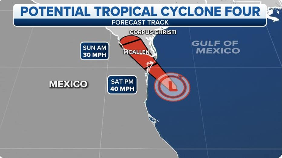
Tracking the tropics(FOX Weather)
The greatest impact will be the potential flooding downpours, for a region that is still drying out from a previous wet weather event. A tropical disturbance last weekend dropped between 3 - 6 inches of rain in the Rio Grande Valley.
The FOX Forecast Center says the rainfall amounts this go around will be lighter but could reach three inches over southern parts of the Lone Star State, with slightly higher amounts in northern Mexico.
The chance of scattered showers and storms associated with the disturbance is expected to diminish by Monday as the system loses any influence from the warm waters of the Gulf of Mexico.
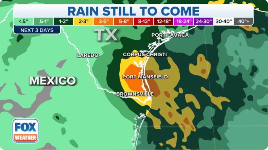
Potential Rainfall(FOX Weather)
The disturbance will also increase seas and cause rough surf along beaches.
The National Weather Service warns the combination of gusty winds and choppy waters is creating a strong rip current risk. Swimmers are encouraged to stay out of the water until the conditions subside.
It's estimated around 100 people die each year from rip currents. If you are caught in a current, it is advised you don’t try to swim against the force outgoing water. Instead, swim parallel to the shoreline until out of the rip current, and then you can safely head back to towards land.
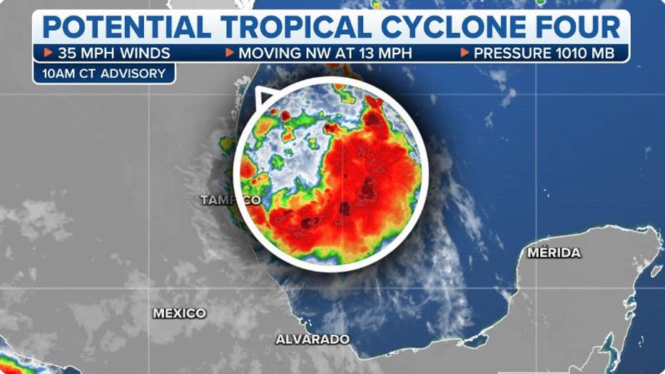
The National Hurricane Center is tracking Potential Tropical Cyclone Four.(FOX Weather)
PEAK OF ATLANTIC HURRICANE SEASON BEGINS IN AUGUST
2022 Atlantic hurricane season off to slow start
The next Atlantic system to become a tropical storm with winds of at least 40 mph will earn the name "Danielle", but we've already passed the date by which the "D" storm would form in an average season (Aug. 15).
In fact, there hasn't been a named storm in the Atlantic Basin since Tropical Storm Colin dissipated in the early-morning hours of July 3. That's a stretch of 46 days as of Friday, which is tied for the third-longest stretch on record without a named storm in the Atlantic during hurricane season.
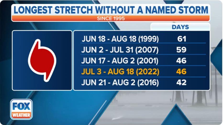
The longest stretches on record without a named storm in the Atlantic Basin during hurricane season.(FOX Weather)
Another benchmark that's been missed in 2022 is the average date of the Atlantic's first hurricane (Aug. 11).
As long as the current lull in tropical activity continues, more benchmarks are in danger of falling.
HURRICANE SEASON 2022 RUNNING BEHIND SCHEDULE: HERE ARE THE IMPORTANT BENCHMARKS TO WATCH FOR
Aug. 22 is the typical date the "E" storm forms, and Aug. 26 is usually when the second hurricane of the season develops, but both dates are in jeopardy of being missed.
As the season marches deeper into August and enters the first month of meteorological fall, these benchmarks become more critical as hurricane season nears the climatological peak of activity on Sept. 10.
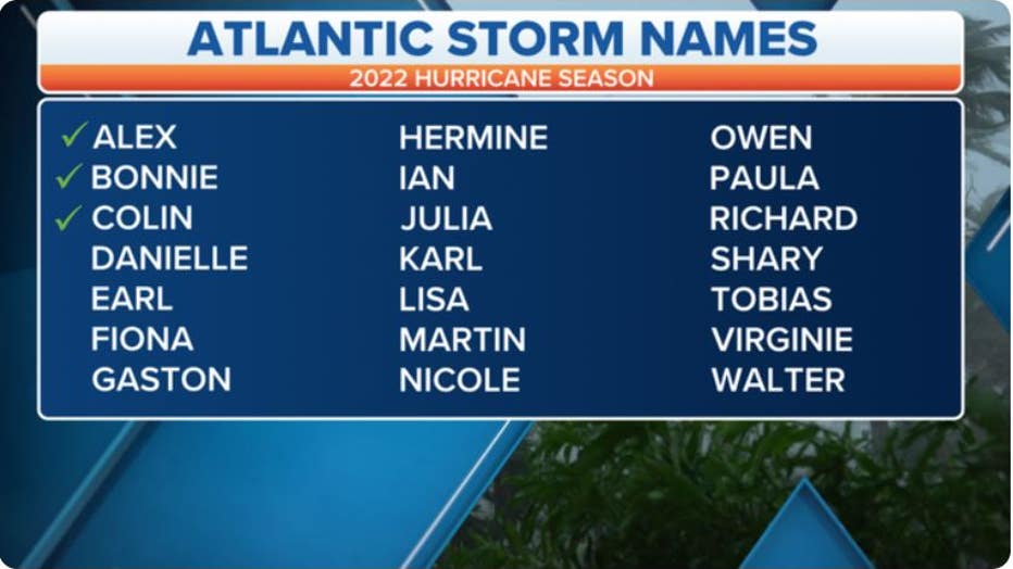
Three tropical storms have formed in the Atlantic during the 2022 season. (FOX Weather)