

Invest 91L to become tropical depression soon as Tropical Storm Philippe gains some strength in Atlantic
Tropical Storm Philippe continues to make its way across the open waters of the Atlantic Ocean, and it could bring some rain and wind to the northern Caribbean islands and Puerto Rico over the weekend while Invest 91L behind it continues to organize and could become a tropical depression or tropical storm as early as Wednesday.
Here's a closer look at the active Atlantic Basin.
Tropical Storm Philippe
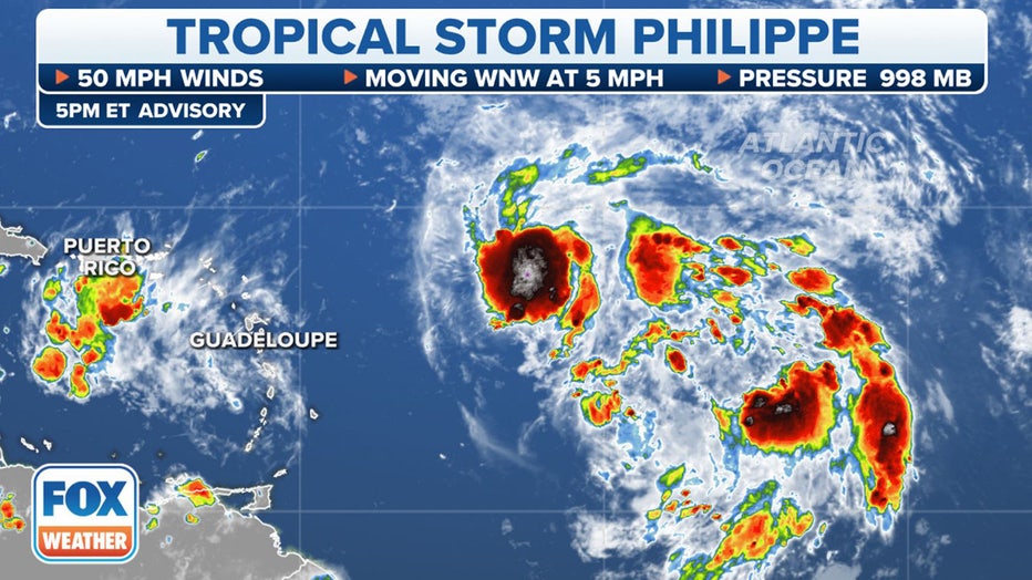
Tropical Storm Philippe's stats. (FOX Weather)
Tropical Storm Philippe continues to spin off to the west through the open waters of the central tropical Atlantic. However, Philippe did get a bit stronger on Wednesday morning and now has maximum sustained winds of 50 mph with higher gusts.
There isn't expected to be much change in Philippe's strength over the next day or two, but slow weakening is expected to begin this weekend.
Philippe is currently 600 miles east of the northern Leeward Islands and is expected to continue moving west-northwest over the next few days. On the current forecast track, Philippe could impact the northern Leeward Islands, the U.S. and British Virgin Islands and Puerto Rico beginning Friday.
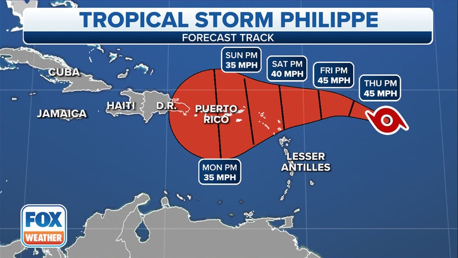
Tropical Storm Philippe's cone. (FOX Weather)
Interests there should monitor the storm's progress as it could bring heavy rain and gusty winds to the region.
Philippe is forecast to dump 2 to 4 inches of rain across the northern Leeward Islands, the Virgin Islands and eastern Puerto Rico between Friday and Monday. Across western Puerto Rico, 1 to 2 inches of rain is predicted. The heavy rain could produce isolated urban and small-stream flooding.
Philippe is the 16th named storm of the 2023 Atlantic hurricane season.
Invest 91L in central tropical Atlantic
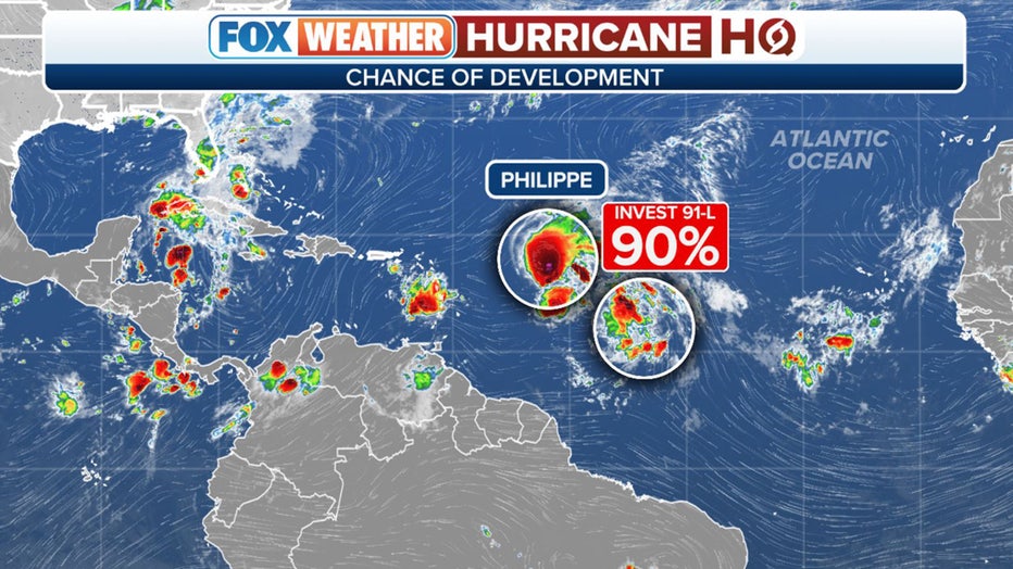
The National Hurricane Center continues to monitor a disturbance halfway between the Cabo Verde Islands and the Lesser Antilles, currently giving it a high chance of development in the next two days.
This disturbance has been dubbed Invest 91L by the NHC.
An invest is simply a naming convention used by the NHC to identify an area of weather that it is investigating for possible development into a tropical depression or tropical storm within the next week.
WHAT IS AN INVEST DURING HURRICANE SEASON?

The outlook for Invest 91L in the central tropical Atlantic. (FOX Weather)
Forecasters said showers and thunderstorms associated with Invest 91L are showing signs of organization on Wednesday. Environmental conditions are expected to be conducive to development, and a tropical depression or tropical storm is likely to form in the next day or so while the system moves west-northwestward across the central tropical Atlantic Ocean.
If it becomes a tropical storm with winds of at least 39 mph, this system will earn the name Rina.
The tropical weather outlook for the Atlantic Ocean. (FOX Weather)