

Category 2 Hurricane Earl generating life-threatening rip currents along US East Coast

People walk through the rain in midtown Manhattan on September 06, 2022 in New York City. (Spencer Platt/Getty Images)
Hurricane Earl is moving away from Bermuda after brushing the archipelago with gusty winds and heavy rain, but even as it heads out into the open waters of the North Atlantic, life-threatening rip currents will continue to spread along the U.S. East Coast.
As of Friday morning, Hurricane Earl was centered less than 200 miles east-northeast of Bermuda with maximum sustained winds estimated at 100 mph – a Category 2 hurricane on the Saffir-Simpson Hurricane Wind Scale, making it the strongest Atlantic tropical cyclone of the season so far.

The current status of Hurricane Earl. (FOX Weather)
Some strengthening is still expected through Friday night, though Earl is no longer predicted to become a major hurricane (Category 3 or stronger).
However, Earl is forecast to transition into a powerful hurricane-force (at least 75 mph) extratropical low-pressure system by Saturday as it heads farther out to sea.
HOW ARE HURRICANES RATED? THE SAFFIR-SIMPSON HURRICANE WIND SCALE EXPLAINED
The projected path and intensity of Hurricane Earl. (FOX Weather)
Due to Earl's close brush with Bermuda, a Tropical Storm Warning remains in effect for the archipelago as strong wind gusts continue Friday morning.
Conditions on Bermuda will quickly improve through the day, but rainfall totals are expected to range from 1 to 3 inches before Earl completely moves away later Friday.
WHAT TO DO WHEN HURRICANE OR TROPICAL STORM WATCHES AND WARNINGS ARE ISSUED FOR YOUR TOWN
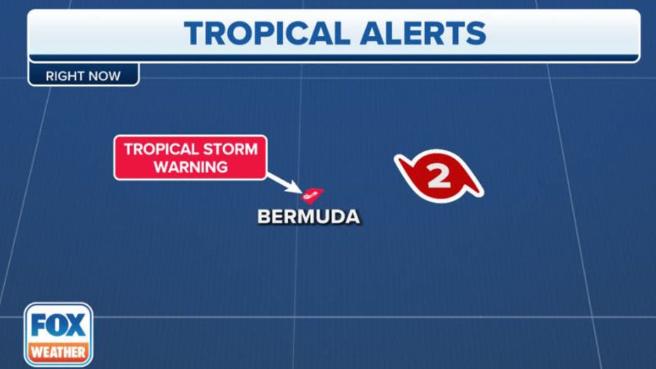
A Tropical Storm Warning remains in effect for Bermuda. (FOX Weather)
Despite passing hundreds of miles off the U.S. East Coast, Hurricane Earl is likely to generate life-threatening rip currents along the Eastern Seaboard for the next several days.
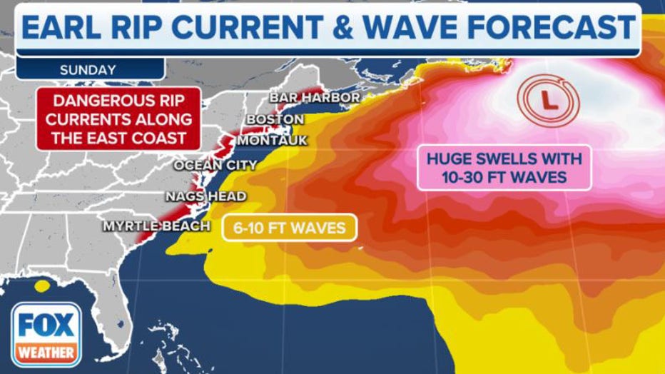
Earl will generate a dangerous rip current threat along the U.S. East Coast. (FOX Weather)
Anyone visiting East Coast beaches should stay out of the surf, as rip currents can sweep even the best swimmers away from shore and into deeper water.
"The key takeaway message for anybody in the U.S. as regards to what we're expecting with Hurricane Earl: Just be careful on the beaches because we do have that rough surf potential that can lead to rip currents and become quite dangerous," FOX Weather meteorologist Jane Minar said.
Three other areas to watch for development
In the central tropical Atlantic, an area of low pressure centered about 1,100 miles east of the Caribbean islands has a well-defined center of circulation. However, strong upper-level winds have caused most of the disorganized shower and thunderstorm activity associated with the low to be displaced well to its northeast.
According to the FOX Forecast Center, strong upper-level winds in this region are forecast to persist for the next several days, so it's becoming less likely that a short-lived tropical depression or tropical storm will form.
The National Hurricane Center currently gives the system a low chance of development. If it does happen to become a tropical storm with winds of at least 40 mph, it will earn the name "Fiona."
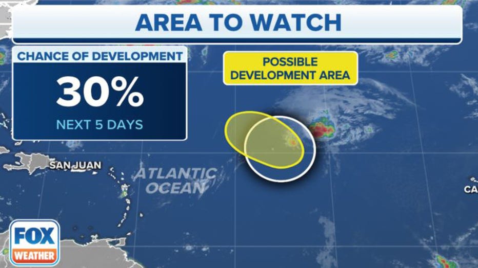
The National Hurricane Center is monitoring the central tropical Atlantic for possible development. (FOX Weather)
WHERE TROPICAL STORMS AND HURRICANES TYPICALLY OCCUR DURING EACH MONTH OF ATLANTIC HURRICANE SEASON
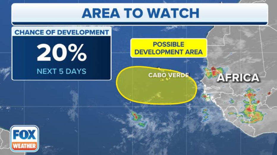
Additionally, a tropical disturbance centered several hundred miles south of the Cabo Verde Islands is producing a disorganized area of showers and thunderstorms.
According to the FOX Forecast Center, any development of this disturbance is expected to be slow to occur as it moves west or west-northwestward at 15 to 20 mph across the eastern and central tropical Atlantic through the middle of next week.
The NHC currently gives the tropical disturbance a low chance of development in the next five days, but those odds could increase beyond the five-day outlook, so be sure to check back for updates.
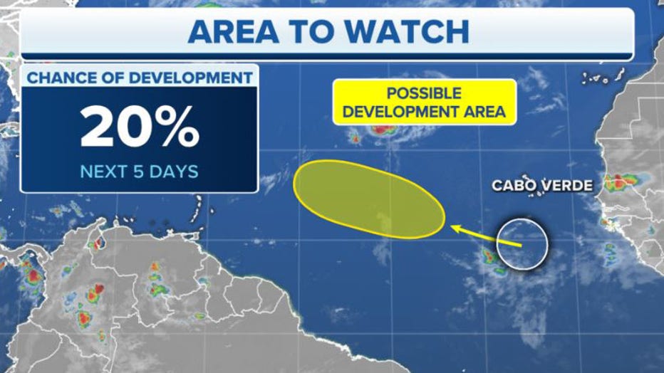
The National Hurricane Center is monitoring the eastern and central tropical Atlantic for possible development (FOX Weather)
Meanwhile, another tropical disturbance is forecast to move off the western coast of Africa by early next week.
According to the FOX Forecast Center, some gradual development of the disturbance will be possible after it emerges over the water and generally heads westward over the far eastern tropical Atlantic.
The NHC currently gives the tropical disturbance a low chance of development in the next five days, but similar to the other tropical disturbance mentioned above, those odds could increase beyond the five-day outlook.
FOX Weather will keep you updated with the latest information on all these areas to watch in the tropics.
The National Hurricane Center is monitoring the eastern tropical Atlantic for possible development. (FOX Weather)