

Hurricane Ian could make landfall along Florida's Gulf Coast as a dangerous major hurricane near Tampa Bay
Visit the FOX Weather Wire for live updates on Hurricane Ian as it barrels toward Florida. Click here for the latest forecast, evacuation orders and more.
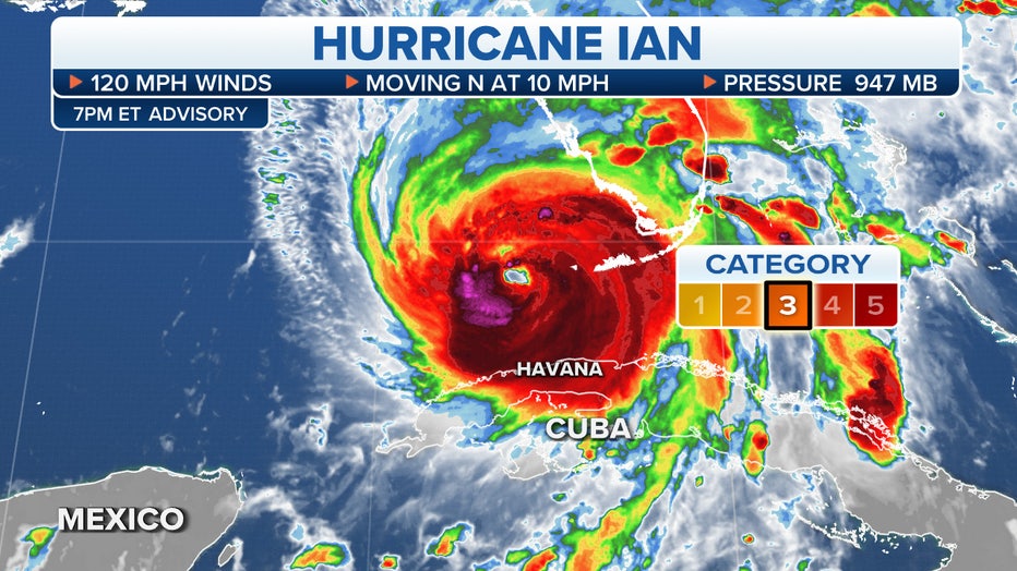
Hurricane Ian strengthened into a Category 3 hurricane as it battered western Cuba early Tuesday morning and is forecast to intensify further, likely reaching Category 4 intensity on the Saffir-Simpson Hurricane Wind Scale as it emerges over the southeastern Gulf of Mexico and heads toward Florida's Gulf Coast.
Ian reached major-hurricane status (Category 3 or stronger) Tuesday morning at 2:30 a.m. Eastern time, then made landfall two hours later in western Cuba at 4:30 a.m. Eastern with maximum sustained winds of 125 mph.
Florida Gov. Ron DeSantis urged Floridians to take precautions and declared a state of emergency for all 67 counties ahead of the impacts of Hurricane Ian. Some mandatory evacuations were ordered Monday in the Tampa Bay area, and Tampa's airport was set to shut down at 5 p.m. Eastern time on Tuesday.

If Hurricane Ian follows a track near the center of the forecast cone shown below, it would be nearly a worst-case scenario for the Tampa Bay area because the powerful winds in Ian's eyewall would plow through the cities of Tampa, St. Petersburg and Clearwater. This track would also push life-threatening storm surge directly into Tampa Bay.
HURRICANES RARELY MAKE DIRECT HITS ON TAMPA BAY BUT THE TROPICS STILL THREATEN
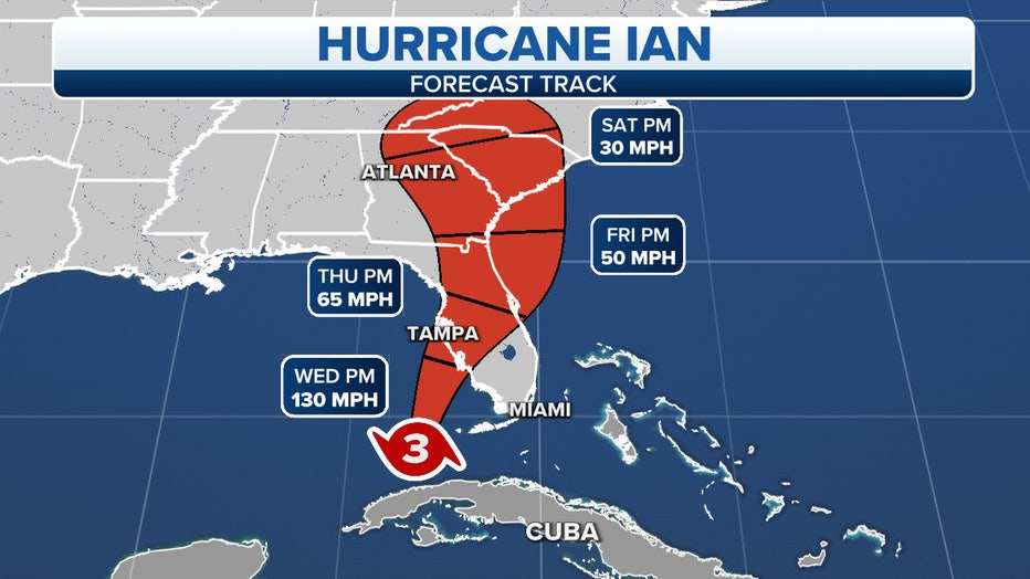
The projected path and intensity of Hurricane Ian. (FOX Weather)
Here's everything the FOX Forecast Center knows about this significant hurricane threat to Florida and the southeastern U.S. this week.
HOW TO WATCH FOX WEATHER ON TV
Where is Hurricane Ian?
Hurricane Ian was blasting western Cuba with destructive winds and torrential rain on Tuesday morning.
Ian was moving northward with maximum sustained winds of 125 mph, making it a Category 3 hurricane on the Saffir-Simpson Hurricane Wind Scale.
The outer bands of Ian brought heavy showers and thunderstorms across the Florida Keys and South Florida on Monday evening as the hurricane approached western Cuba. An anemometer just offshore from Marathon in the Florida Keys registered a tropical-storm-force wind gust of 39 mph on Monday evening.
Hurricane Ian's outer rainbands lashed Grand Cayman in the Cayman Islands earlier Monday. Wind gusts as high as 53 mph were reported on this largest island of the Caymans.
KNOW YOUR ZONE: FLORIDA EVACUATION MAP SHOWS WHO WILL HAVE TO LEAVE BEFORE A HURRICANE STRIKES
Tracking Hurricane Ian.
Where are watches and warnings in effect?
Hurricane Warnings have been issued along the Gulf Coast of Florida from Bonita Beach northward to the Anclote River, which includes the Tampa Bay area and the Dry Tortugas.
A Hurricane Warning means that sustained winds of at least 74 mph are expected in the warning area. Preparations to protect life and property should be rushed to completion.
Hurricane Watches have been issued farther north along Florida's Gulf Coast from north of the Anclote River to the Suwannee River.
A Hurricane Watch means that sustained winds of at least 74 mph are possible in the watch area. A watch is typically issued 48 hours before the anticipated first occurrence of tropical-storm-force winds (39-plus mph), conditions that make outside preparations difficult or dangerous.
Tropical Storm Warnings have been issued for the lower Florida Keys from the Seven Mile Bridge westward to Key West, from Flamingo to Bonita Beach, from the Suwannee River to the Anclote River, from the Volusia/Brevard County line southward to Jupiter Inlet and for Lake Okeechobee.
A Tropical Storm Warning means that sustained winds of at least 39 mph are expected in the warning area.
Tropical Storm Watches are in effect from north of the Suwannee River to Indian Pass in Florida, from Altamaha Sound in Georgia to the Volusia/Brevard County line in Florida and from Deerfield Beach to Jupiter Inlet in Florida.
A Tropical Storm Watch means that sustained winds of at least 39 mph are possible in the watch area, generally within 48 hours.
WHAT TO DO WHEN HURRICANE OR TROPICAL STORM WATCHES AND WARNINGS ARE ISSUED FOR YOUR TOWN
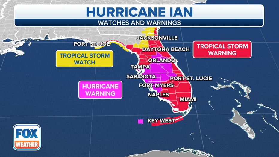
Current watches and warnings in effect for Hurricane Ian.
Storm Surge Warnings have been issued along Florida's Gulf Coast from the Anclote River southward to Flamingo, which includes Tampa Bay.
A Storm Surge Warning means there is a danger of life-threatening inundation, from rising water moving inland from the coastline, in the indicated locations. Anyone living within these areas should take all necessary actions to protect life and property from rising water and the potential for other dangerous conditions.
Storm Surge Watches have been issued for the Florida Keys from the Card Sound Bridge westward to Key West, for the Dry Tortugas, for Florida Bay, from the Aucilla River to the Anclote River in Florida, from Altamaha Sound in Georgia to the Flagler/Volusia County line in Florida and for the Saint Johns River in Florida.
A Storm Surge Watch means there is a possibility of life-threatening inundation, from rising water moving inland from the coastline, in the indicated locations during the next 48 hours.
WATER FROM HURRICANES, TROPICAL STORMS KILLS MORE IN U.S. THAN WIND
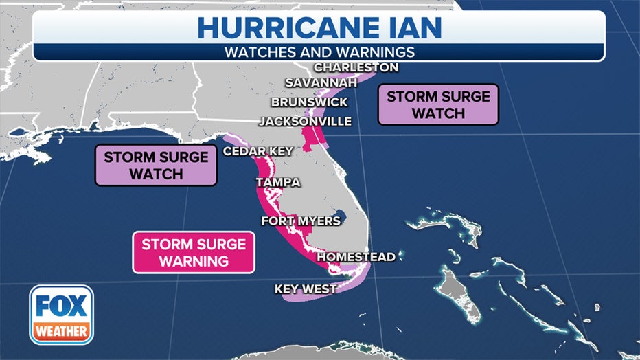
Storm Surge Watches and Warnings are in effect along the path of Hurricane Ian. (FOX Weather)
In the Caribbean, a Hurricane Warning is in effect for the Cuban provinces of Isla de Juventud, Pinar del Rio and Artemisa.
A Tropical Storm Warning has been issued for the Cuban provinces of La Habana, Mayabeque and Matanzas.
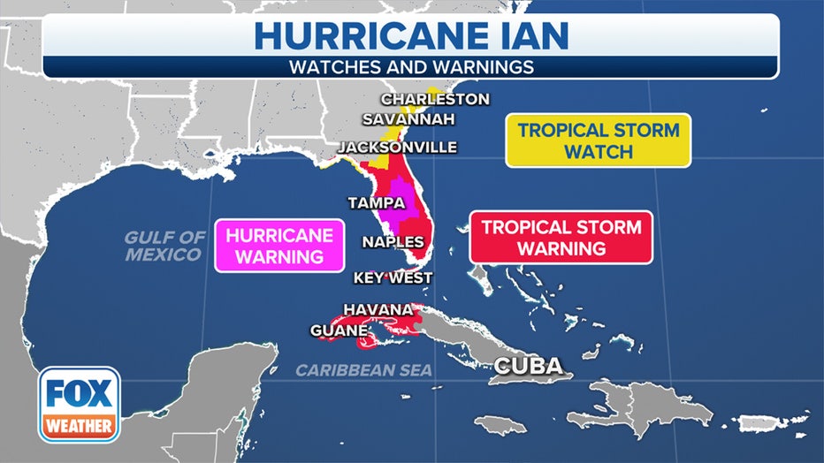
Current watches and warnings in effect for Hurricane Ian.
What is the forecast for Hurricane Ian?
The FOX Forecast Center expects Ian to intensify into a Category 4 hurricane in the southeastern Gulf of Mexico later Tuesday as it pulls away from western Cuba.
Hurricane Ian is forecast to slow down in forward progress as it gets closer to landfall along Florida's Gulf Coast, which would make the wind, rain and storm surge impacts persist for a longer period of time.
Ian is also expected to remain a large hurricane, so regardless of its exact intensity at landfall, it will still be capable of significant impacts whether it's a Category 3 hurricane or only a Category 1 or 2 hurricane on the Saffir-Simpson Hurricane Wind Scale.
And due to Ian's large size, impacts are likely to occur outside the forecast cone. These impacts are predicted to arrive well before the center of the hurricane makes landfall.
HERE ARE THE BUZZWORDS YOU'LL BE HEARING DURING HURRICANE SEASON
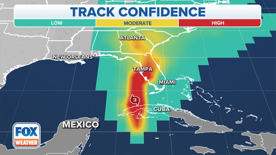
Hurricane Ian's track confidence through Friday.
What are the expected impacts of Hurricane Ian in Florida and the southeastern US?
Tropical-storm-force winds (39-plus mph) are expected in the Tropical Storm Warning areas in the lower and middle Florida Keys beginning later Tuesday.
Hurricane-force winds (74-plus mph) are expected to arrive along Florida's Gulf Coast within the Hurricane Warning areas on Wednesday morning, with tropical-storm-force winds possibly beginning by late Tuesday.
Tropical-storm-force winds are expected to begin in the Tropical Storm Warning areas along the southwestern coast of the Florida Peninsula by Tuesday evening, then along the Gulf Coast of Florida north of the Tampa Bay area and along portions of the Atlantic coast of Florida on Wednesday.
Hurricane-force winds are possible in the Hurricane Watch areas along the northwestern coast of the Florida Peninsula beginning on Wednesday, with tropical-storm-force winds possible in the Tropical Storm Watch areas of Florida and Georgia from Wednesday into early Thursday.
TRACK HURRICANE IAN WITH THESE MAPS
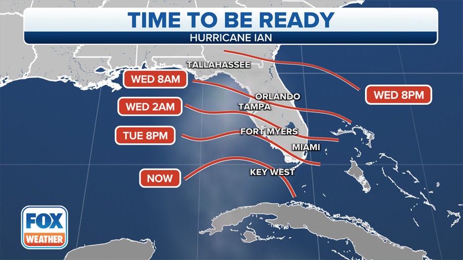
Here's when final Hurricane Ian preparations should be complete. (FOX Weather)
The large size of Hurricane Ian, in combination with its potential to slow down in forward progress as it approaches Florida's Gulf Coast, will increase the threat of life-threatening storm surge, regardless of the hurricane's intensity at landfall.
According to the National Hurricane Center, the water could reach the following heights above ground somewhere in the indicated areas if the peak surge occurs at the time of high tide:
- Anclote River to Bonita Beach, Florida, including Tampa Bay and Charlotte Harbor: 5 to 10 feet
- Suwannee River to Anclote River: 5 to 8 feet
- Bonita Beach, Florida, to Chokoloskee, Florida: 4 to 7 feet
- Chokoloskee, Florida, to East Cape Sable, Florida: 3 to 5 feet
- Flagler/Volusia County line in Florida to Altamaha Sound in Georgia, including the St. Johns River in Florida: 2 to 4 feet
- East Cape Sable, Florida, to Card Sound Bridge, Florida, including Florida Bay: 2 to 4 feet
- Aucilla River to Suwannee River in Florida: 2 to 4 feet
- Florida Keys, including the Dry Tortugas: 2 to 4 feet
- Indian Pass, Florida, to Aucilla River, Florida: 1 to 3 feet
Storm-surge flooding might begin as soon as late Tuesday in far South Florida, then along the rest of Florida's Gulf Coast by Wednesday.
The peak surge is expected to occur near and south of where Hurricane Ian makes landfall on the Gulf Coast of Florida.
WHY FLORIDA'S GULF COAST IS SUSCEPTIBLE TO A HURRICANE'S STORM SURGE
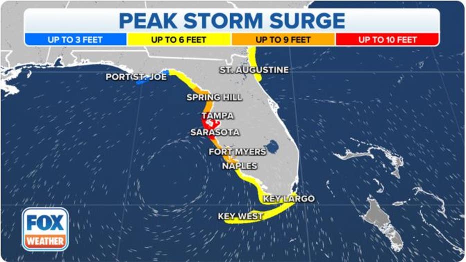
The predicted peak storm surge from Hurricane Ian in Florida. (FOX Weather)
Bands of locally heavy rain were already spreading into portions of the Florida Peninsula on Tuesday. This heavier rain will gradually spread northward up the Peninsula in the days ahead and eventually into the Florida Panhandle and parts of the Southeast by late week and into this weekend.
Between 12 and 16 inches of rain is expected in western portions of Central Florida, with isolated amounts up to 24 inches possible.
The rest of the Florida Peninsula is projected to pick up 5 to 10 inches of rainfall, with localized amounts up to 12 inches. The Florida Keys are forecast to receive 4 to 6 inches of rainfall, with isolated totals up to 8 inches.
Widespread considerable flash and urban flooding are expected mid- to late week across Central and North Florida, South Georgia and coastal South Carolina. Significant, prolonged river flooding is also expected across Central and North Florida.
Flash and urban flooding are also expected with Hurricane Ian's heavy rainfall across South Florida through midweek.
Limited flash and river flooding are expected over portions of the southeastern U.S. and into the mid-Atlantic states mid- to late week.
HOW TO PREPARE FOR A HURRICANE
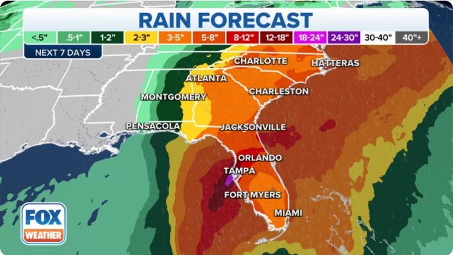
Rainfall forecast from Hurricane Ian. (FOX Weather)
Florida's emergency management agency is advising residents to prepare for the coming storm now. Floridians can check their evacuation zone by typing their address into an interactive map.
The FOX Forecast Center will be keeping a close eye on Hurricane Ian as it strengthens and tracks in the direction of Florida's Gulf Coast this week.
Visit the FOX Weather Wire for live updates on Hurricane Ian as it barrels toward Florida.