More evacuations ordered due to Arizona river flooding: Live radar, updates

New evacuations ordered in Camp Verde due to flooding
Evacuation orders in Sedona were lifted after Wednesday night's storm slammed the town, causing major flooding. Now, the town of Camp Verde has issued new mandatory evacuation orders.
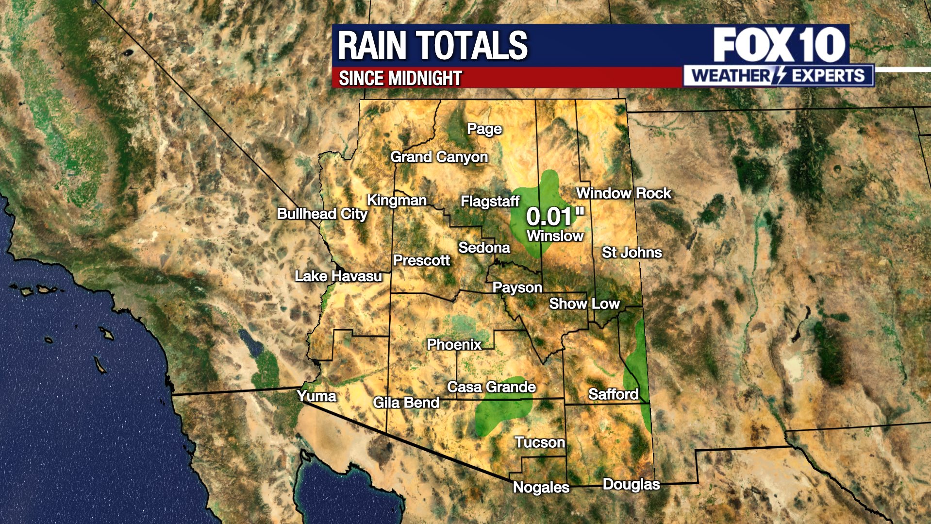
PHOENIX - Another storm is bringing more rain across Arizona, with showers expected in the Valley and in the high country. We have the latest weather updates for the Valley and other parts of the state.
Phoenix area
The Phoenix metropolitan area saw widespread rain and thunderstorms on Wednesday.
This new round of storm came as parts of the Phoenix area are affected by flooding due to a release of water from reservoirs away from the Valley. Water levels are high at those reservoirs due to rain in the high country, mixed with already packed snow.
The Gila River overflowed, closing down several roads in Avondale. Water flowing down from the Verde River to the Salt River eventually ended up there.
"We went into this warmer pattern earlier this week, and over the weekend, that resulted in that snowpack starting to melt, and come down through our river systems," said Tom Frieders, Warning Coordination Meteorologist for the National Weather Service in Phoenix.

Rain and snowmelt from Arizona's High Country flood into the Valley
Heavy rain in recent weeks, along with snowmelt from warmer weather in recent days, mean water is being released from reservoirs, and that is responsible for flooding conditions in parts of the Valley. FOX 10's Marissa Sarbak reports.
Officials with SRP have started low-level water releases from Bartlett Dam, which is located 50 miles northeast of Phoenix. Water from the dam flowed down from the Verde River to the Salt River, and eventually made its way to the Gila River in Avondale.
Freiders said the water will continue to move downstream, but he also said he can't pinpoint exactly where the water will end up.
According to Maricopa County, roads will reopen when the water recedes enough for cars to safety pass through.
MORE: Water released from reservoirs causing flooding on some Arizona roadways
Evacuations ordered

Latest round of storm prompts evacuation orders in Yavapai County
A new round of storm on Mar. 15 brought rain to various parts of Arizona, and the storm has resulted in flooding in some places. FOX 10's Marissa Sarbak reports.
Evacuation orders were issued in Camp Verde on Thursday due to flooding on the Verde River.
Residents near North Verde River Drive west of I-17, the Verde River RV Resort, and the Wagon Wheel Trailer Park are affected by the order.
An evacuation shelter has been arranged at 280 Camp Lincoln Road. Emergency management crews can be reached at 928-442-5103.

Flooding in Sedona: Rising water levels at Oak Creek forces evacuations
FOX 10's Anita Roman visits Sedona to check out the flooding in Oak Creek. A number of communities have been asked to evacuate due to the rising water levels.
A flood warning for Oak Creek in Sedona was downgraded to an advisory Thursday, hours after some residents were told to prepare for evacuations.
The City of Sedona said in a statement around 6 p.m. Wednesday that a dozen areas including the Rancho Sedona RV park and the Center for the New Age were in "go" status, meaning they should evacuate immediately.
A shelter for the area was set up at the gym of Camp Verde Middle School as a precaution.
But the National Weather Service in Flagstaff said only minor to moderate flooding was expected Thursday along Oak Creek, Wet Beaver Creek, the Verde River and the Little Colorado River.
The weather agency said that because of snowmelt at higher elevations and rain, minor to moderate flooding was forecast along Oak Creek affecting access roads, buildings and residences.
The creek was nearing a flood stage level of 14 feet Wednesday evening, but weather officials said water had receded to about 9 feet by 4 a.m. Thursday.
Water levels in Oak Creek rose fast, overflowing roads and making them impassible.
"The gauge at Tlaquepaque, which is up the creek just a little bit in the middle of Sedona, is a little bit over 9 feet," said Sedona Assistant Fire Chief Jayson Coil. " 9 feet is about 10th or 12th in historic crests. If the creek rises to the level that they expect it to for this event, that would be 15 feet, and that would put it at the fourth highest that it’s ever been."
Coil says everyone, but especially visitors, need to pay attention to the overflow areas.
"Parts of the roadway can wash away, and then people will drive across it and then they’ll get off the roadway," said Coil. "Once the water hits the side of your vehicle, you’re done."
Coil said it will take emergency crews time to find a person, and then more time to safely rescue them. Time, however, is not something people always have.
"Unless you can get out and on top of that vehicle and out of that cold water, you’ll probably die before we can find you," said Coil.
Road closures
A rockslide has shut down State Route 89A between Sedona and Flagstaff. There is no estimated time to reopen the lanes.
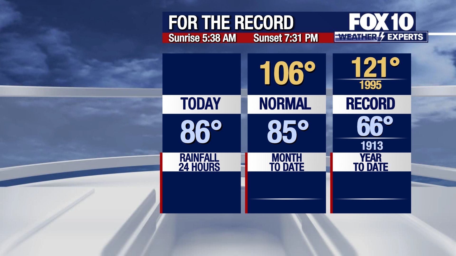
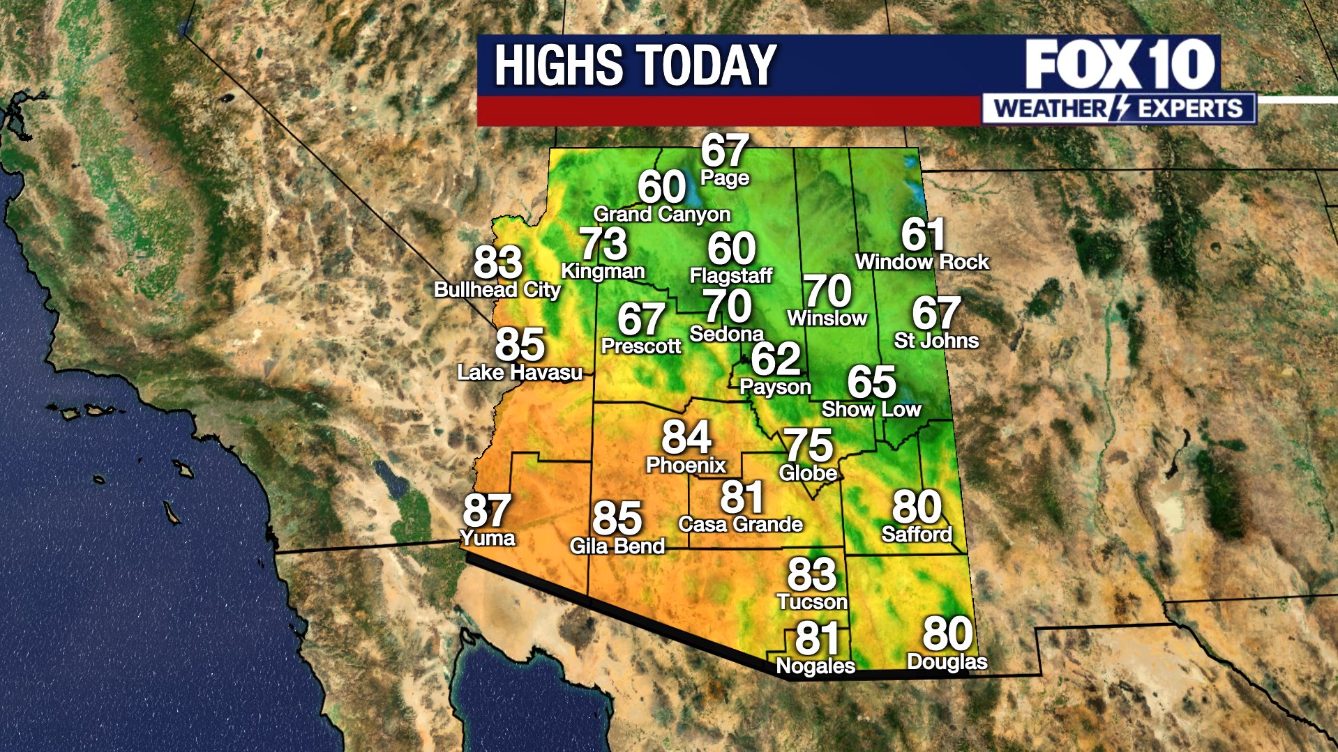
Latest forecast

MORE: Arizona weather forecast: Rain, stormy weather ahead for the state
Latest updates
You can always check the latest weather conditions by visiting the FOX 10 Phoenix weather page, or download the Free FOX 10 Weather app, which is available on Apple iOS and Android.
Scroll down this page for satellite and radar, day planner, records, current temperatures, 10-day forecast, forecast highs, and recent rainfall totals, plus live video feeds.