Flood Watch
until MON 5:00 AM MST, Yavapai County Mountains, Little Colorado River Valley in Navajo County, Western Mogollon Rim, Coconino Plateau, Chinle Valley, Yavapai County Valleys and Basins, Oak Creek and Sycamore Canyons, Grand Canyon Country, Chuska Mountains and Defiance Plateau, Northeast Plateaus and Mesas South of Hwy 264, Little Colorado River Valley in Coconino County, Black Mesa Area, Marble and Glen Canyons, Northeast Plateaus and Mesas Hwy 264 Northward, Northern Gila County, White Mountains, Kaibab Plateau, Eastern Mogollon Rim, Little Colorado River Valley in Apache County, Eastern Cochise County below 5000 ft including Douglas/Wilcox, Upper Gila River and Aravaipa Valleys including Clifton/Safford, Southeast Pinal County including Kearny/Mammoth/Oracle, Western Pima County including Ajo/Organ Pipe Cactus National Monument, Dragoon/Mule/Huachuca and Santa Rita Mountains including Bisbee/Canelo Hills/Madera Canyon, Tucson Metro Area including Tucson/Green Valley/Marana/Vail, Tohono O'odham Nation including Sells, Baboquivari Mountains including Kitt Peak, Upper San Pedro River Valley including Sierra Vista/Benson, Chiricahua Mountains including Chiricahua National Monument, Galiuro and Pinaleno Mountains including Mount Graham, Santa Catalina and Rincon Mountains including Mount Lemmon/Summerhaven, White Mountains of Graham and Greenlee Counties including Hannagan Meadow, South Central Pinal County including Eloy/Picacho Peak State Park, Upper Santa Cruz River and Altar Valleys including Nogales, North Phoenix/Glendale, Aguila Valley, Mazatzal Mountains, Tonopah Desert, Gila Bend, San Carlos, East Valley, Northwest Pinal County, Northwest Valley, Southeast Valley/Queen Creek, Globe/Miami, Deer Valley, Fountain Hills/East Mesa, Apache Junction/Gold Canyon, Buckeye/Avondale, Tonto Basin, Rio Verde/Salt River, South Mountain/Ahwatukee, Dripping Springs, Southeast Gila County, Pinal/Superstition Mountains, Scottsdale/Paradise Valley, New River Mesa, Sonoran Desert Natl Monument, West Pinal County, Superior, Cave Creek/New River, Central Phoenix, Northwest Plateau, Lake Havasu and Fort Mohave

1 dead, 1 injured in small plane crash near Page

Authorities say one person was killed when a small plane crashed Wednesday near the Arizona-Utah border.

Coconino County sheriff’s spokesman Jon Paxton said the plane crashed between 5-6 p.m. on Sept. 22 in the Pariah Plateau area near Page. The initial emergency call indicated that a plane from San Martin, California, had gone down while on the way to Page Airport.

Two people were on board at the time of the crash –  the pilot who died, and one other person who was flown to a Utah hospital for treatment.

The pilot was identified as Jim Petersen, and the passenger was identified as Uta Petersen.

The National Transportation Safety Board identified the plane as a Piper PA28R-200. The NTSB and Federal Aviation Administration will investigate the cause of the crash.

Page is 242 miles (389 kilometers) north of Phoenix and just south of the Arizona-Utah border.
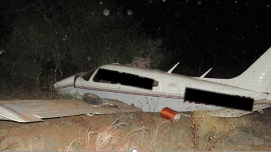
Plane crash site at Paria Plateau (Coconino County Sheriff's Office) (Plane crash site at Paria Plateau)

The Associated Press contributed to this report.

Arizona Headlines


Tune in to FOX 10 Phoenix for the latest news:

Get breaking news alerts in the FREE FOX 10 News app. Download for Apple iOS or Android.

Coconino CountyAlertsNews