

Remnants of Hurricane Nora bring rain to Arizona; Flash Flood Watches issued

Morning Weather Forecast - 9/2/21
Things will dry out today in the Valley and we'll see a high near 98°F.
PHOENIX - Flash Flood Watches have been issued for all of Arizona as remnants from Hurricane Nora brought heavy rain to the state.
Increasing tropical moisture will produce showers and thunderstorms capable of producing heavy rainfall, with the threat increasing Tuesday afternoon and continuing into Wednesday, the National Weather Service said.
"Copious moisture from the remains of Nora moving into the region will still produce widespread TS activity across the region Tue/Wed.," NWS Phoenix said in a tweet.
Forecasters said locally heavy rainfall of up to 2 inches (5 centimeters) per hour combined with saturated ground will likely result in flash flooding in normally dry washes, small streams and poor drainage areas.
Low-water crossings are particularly vulnerable to flooding while burn scars from past wildfires are a particular concern because they’re prone to flash flooding and debris flow, the weather service said.
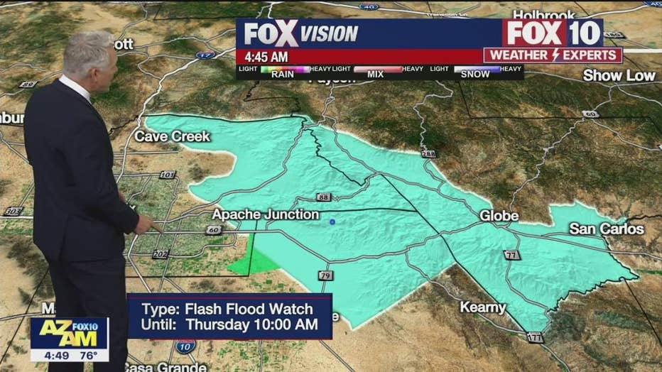
A Flash Flood Watch remains in effect until the morning of Sept. 2.
The Arizona Department of Transportation said particular areas of concern were southern Arizona, the Tonto Basin in hill country east of metro Phoenix and along U.S. 60 near Globe.
The department said its maintenance crews across the state have been preparing for the expected storms by clearing debris from drainage systems and checking the more than 55 pump stations along Phoenix-area freeways.
Crews also staged heavy equipment in areas prone to flooding to allow faster responses, the department said.
Phoenix Sky Harbor International Airport on Tuesday saw a new record low of 75 degrees.
The Flash Flood Watch is scheduled to last until early Thursday morning for the Phoenix area.
RELATED: Monsoon storm making its way over Arizona once again
Hurricane Nora formed off Mexico’s Pacific coast Saturday and swept past the Puerto Vallarta area.
Nora had maximum sustained winds of 75 mph (120 kph) late Saturday, with tropical storm force winds extending out 105 miles (165 kilometers). It was centered about 50 miles (85 kilometers) north-northwest of Puerto Vallarta, and heading to the north at 16 mph (26 kph).
Forecasters warned that people along Mexico’s central and northern Pacific Coast should be alert to the dangers of flooding, mudslides and perilous surf. Authorities in Mexico’s Jalisco state, where Nora made a brief landfall crossing the cape south of Puerto Vallarta, said there were no early reports of serious damage.
The weakened remnants might bring rains next week to the U.S. Southwest and central Rockies, forecasters said.
The U.S. National Hurricane Center said Nora was expected to drag along the coast and gradually weaken to a tropical storm by Sunday night before heading into the narrow Gulf of California, passing close to the mainland resort area of Mazatlan. It was predicted to keep moving north, before weakening further and heading inland toward the Arizona border region.
The Associated Press (AP) contributed to this report.
You can check the latest weather conditions by visiting the FOX 10 Phoenix weather page, or download the Free FOX 10 Weather app, which is available on Apple iOS and Android.

Road Conditions
- Call 511 anywhere in Arizona or 1-888-411-ROAD (7623)
- az511.com
Rain/flood safety tips
The American Red Cross' tips for heavy rain situations and flood safety:
- Turnaround don’t drown! If you must drive and you encounter a flooded roadway, turn around and go another way.
- If you are caught on a flooded road and waters are rising rapidly around you, get out of the car quickly and move to higher ground.
- Tune in to your local radio, NOAA radio, or news channels for the latest updates.
- If your neighborhood is prone to flooding, be prepared to evacuate quickly.
- Follow evacuation orders and do not attempt to return until officials say it is safe.
- If power lines are down, do not step in puddles or standing water.
- If power is out, use a flashlight. Do not use any open flame as alternate lighting.
Be prepared and stay safe during the monsoon
"Most Valley residents know how quickly and furiously storms can move in and out, bringing strong winds, dust, rain, and flash flooding. These storms can cause interruptions in services, such as water, power, and gas," stated Captain Ashley Losch of the Glendale Fire Department.
GFD reminds residents of ways they can be prepared and stay safe:
- Have flashlights with extra batteries on hand.
- Have food that can be prepared without the need for cooking or refrigeration.
- Have at least one gallon of clean water for each person in the household.
- Have backup power for anyone requiring power for a medical device.
- Have backup power for cell phones that do not require charging.
- Have a first aid kit ready and accessible.
- Never drive into areas with flowing water; it takes less than 10 inches to wash a car away.
- Avoid flooded areas, such as washes.
- If waters are rising, seek higher ground.
- Do not approach downed power lines, the ground can be energized for up to 200 feet.
- Keep pets indoors during storms.
More weather news
- Arizonans land in Louisiana to help victims of Hurricane Ida
- United Cajun Navy assists with Hurricane Ida rescue efforts in Louisiana
- Hurricane Ida hits Louisiana on anniversary of Hurricane Katrina
Tune in to FOX 10 Phoenix for the latest news:
Get breaking news alerts in the FREE FOX 10 News app. Download for Apple iOS or Android.